Contour lines join points of equal elevation. Lines close together mean steep ground; lines far apart mean gentle ground. The contour interval on the map margin tells you how much height each line represents, and the shapes the lines make show ridges, valleys, peaks, and saddles.
- Close contour lines mean steep; wide spacing means gentle.
- V-shaped contours point uphill in valleys and downhill on ridges.
- Check the contour interval and scale in the margin first.
- Carry a paper map and compass even if you navigate by phone.
Start with the margin
- Scale. On US Geological Survey 1:24,000 maps, one inch on the map equals 2,000 feet on the ground.
- Contour interval. The height difference between neighboring contour lines, such as 40 feet.
- Declination. The angle between true north and magnetic north, which you need for compass work.
- Legend. Symbols for trails, roads, water, and vegetation.
Contour lines and steepness
Every point on one contour line sits at the same elevation. Every fifth line is usually drawn darker and labeled with its elevation; these are index contours. Count lines between two points and multiply by the interval to find the climb.
Field tipBefore a hike, count the contour lines your route crosses. A trail that crosses many lines in a short distance will be steep.
Reading the shapes
| Shape | Feature |
|---|---|
| Small closed circles | A peak or hilltop |
| V or U shapes pointing uphill | A valley or drainage; streams run through the point of the V |
| V or U shapes pointing downhill | A ridge or spur |
| An hourglass between two high points | A saddle or pass |
| Lines merging or touching | A cliff |
Match the map to the land
- Orient the map. Turn it until north on the map points north, using a compass or obvious landmarks.
- Find two or three features. Peaks, lakes, and trail junctions you can see.
- Locate yourself. Match what you see to the shapes on the map.
- Check as you go. Tick off features such as stream crossings and junctions.
Phone, GPS, and paper
Phone mapping apps with downloaded offline maps are excellent, but batteries die and screens break. Carry a paper map of the area and a basic compass, and practice using them on easy trails before you need them.
A few good questions.
What do contour lines close together mean?
Steep terrain. The closer the lines, the faster the elevation changes.
What is a contour interval?
The vertical distance between neighboring contour lines, printed in the map margin, for example 40 feet.
How do you tell a valley from a ridge on a topo map?
In valleys, V-shaped contours point uphill, often with a stream through them. On ridges, they point downhill.
What scale are USGS topo maps?
The standard US Geological Survey quadrangle maps are 1:24,000, where one inch equals 2,000 feet.
Gear that helps.
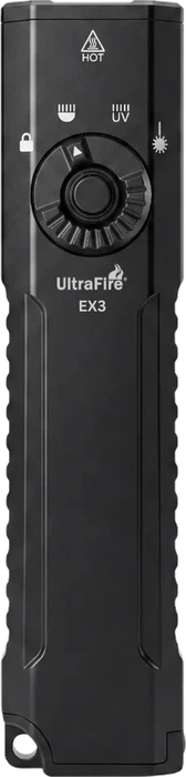
UltraFire EX3 Flat EDC
Best forHikers and campers who want a flat pocket light with white, UV, and laser modes in one body
A flat, 127g pocket flashlight that combines a 1,000-lumen warm white beam, 395nm UV, and a green laser behind a rotary selector, with a digital battery readout and USB-C charging.
Price today $43.99 · Partner code lists 8% off; product eligibility is not listed.
Price checked October 17, 2026 · UltraFire US store · Store sale price for all three colors (list $59.99); tax and shipping shown at checkout. The partner record does not list product eligibility.
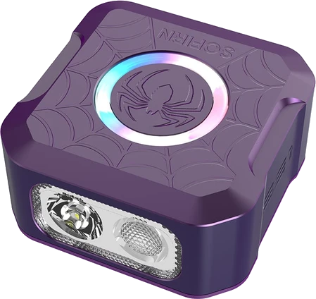
SOFIRN SE1
Best forCampers and everyday carriers who want a clip-on light for quick tasks
We like the SOFIRN SE1 as a compact companion for campsite jobs and everyday carry: quick-release mounting, USB-C charging, and a colorful signal ring, with a 300-lumen boost for short tasks.
The official US product endpoint marks all listed SE1 variants sold out. The code offers free shipping, not a reduction to the item price Checked October 16, 2026.
Read our verdictOur approach
Written by Outdoor Gear Verdict Editorial. Grounded in US Geological Survey topographic map conventions. Always follow local regulations and the manufacturer instructions for your equipment. Read our editorial standards.